Finding South Visayas

Of the three ships marshaled by capitan general Álvaro de Saavedra, only the flagship Florida had survived the insidious violence of the Pacific and reached Mindanao in late February 1528. They were despatched by Hernan Cortes, Viceroy of New Spain and conqueror of Mexico, with the task of assisting what was left of the expedition helmed by García Jofre de Loaisa that departed Spanish shores three years earlier. Loaisa was entrusted to further explore Spain’s commercial potentials in the spice islands, but things went amiss early on in the journey. Only four of the seven ships that he originally left with had reached the Pacific ocean, and one, Santiago, headed north instead, to Mexico, to seek rest and repairs and deliver morbid tidings to Cortes of what had happened and what is not known to have happened thereafter. So Saavedra was now where Loaisa and the rest were supposed to have been, but there were no signs of any of them. Until, on Ash Wednesday, they saw a man speeding through the sand towards their ship, shouting words that sounded familiar, fairly intelligible from a distance. Realising that this vagrant was insistent on being heard, Saavedra granted him audience. It turns out that they could, indeed, understand what the man was trying to say because he was speaking in Spanish and was a native of Spain.
His name was Sebastian de Puerta.
Puerta was a forlorn member of the Santa María de Parral, one of the four Loaisa ships that made it out of Magellan’s straight. While at sea, the Santa María de Parral lost sight of the others and got estranged. Fortunately, the crew continued to sail westwards, eventually finding Mindanao and docking there. Unfortunately, the locals were feeling a bit under the weather, later deciding to attack the Spaniards, killing their captain Jorge de Manrique in the process. Puerta was one of the few survivors that were spared the carnage, awarded an extension of mortality in exchange for their servitude. Puerta recalls that after being detained, he was sold as a slave to a merchant who had business dealings in Cebu. His master took him there in one of his business jaunts, and it is there that Puerta received news of Magellan’s remaining crew. He reports that they were all sold as slaves to the Chinese in exchange for “unos bacanes de metal” (“some splendid pieces of metal”). No other news of their fate is known, but what Puerta does know is the name of the island the Santa María de Parral landed on. According to his testimony, recorded in Fransisco Granado’s recollection of the Saavedra voyage, they settled on an “isla que se dice Vizaya” (“island called Vizaya”).1
The Philippine archipelago is neatly divided into three main regions: Luzon, Visayas, and Mindanao. Of the three regions, Visayas is the only one that isn’t named after a single huge landmass. Geologically, it is a set of nearby islands separated by navigable waters that resemble the workings of a vibrant circulatory system, wherein the seas separating these islands act as arteries that supply the region with saline vitality, fostering the easy movement of communities, customs, and commodities from one island to another. Essentially, these waters nurtured Bisaya pelagic proficiency. The Bisaya of yore were heralded by the Spaniards as excellent seafarers and shipwrights.2 They cruised to nearby coasts on their swift, sturdy boats, establishing new settlements on unfamiliar soil when they found it habitable, only later to enjoy the hospitality of the hostile locals. Often they nominated to go back home after a successful sojourn instead of staying put, victoriously returning with lucrative booty and, most important, live human bodies since slaves were one of their prized loots. The widespread lateral distribution of Bisaya communities from the largest westernmost island in the neighbourhood, Panay, to the easternmost, Samar, gave the region its name.
A cursory look at a modern map, however, casts an incredulous gaze on the naval competence of the ancient Bisaya, because if they were truly maritime maestros, wouldn’t the extent of their distribution be even wider, thereby enlarging the region? The regional scope of the Visayas today suggests that they didn’t stray too far, hinting that they were incapable of navigating longer distances. But contemporary demarcations do not reflect ancient divisions. Geographical information back then does not entirely accord with what is known today, for time is known to smear human thought with its indelible ink: at times erasing, other times adding.
Before time could mar memories, humans, too, use ink and other implements to record all that they’ve seen, read, learned, experienced, and imagined; vivifying inanimate pages with words and illustrations. And thus, where maps can only show, manuscripts will have to tell all. Puerta’s identification of an area in Mindanao as “Vizaya” uncovers a forgotten Bisaya expansion and expedition to or from the south heretofore buried in seldom consulted documents.
That one of the earliest mentions of Visayas should come from a foreign sailor and not from a Bisaya is unsurprising. Little is known about the writing habits of the Bisaya. Instead of ink, they mainly used their voices to channel their stories down the ages, mostly through songs and incantations.3 Perhaps a fuller song of Vizaya may have echoed out their lips, but by the time Puerta set foot on Mindanao, only its name had remained, and it is this verbal fragment that Puerta related to Granado who then committed it to print. Luckily, another member of the unlucky Loaisa voyage had heard of Vizaya and himself noted it down. His experiences in the archipelago are also awash in misfortune and misery, but not as wretched as that of Puerta for he would come back to the archipelago for a second stint. In fact, his figure stands tall among the pantheon of Spanish explorers for he was fundamental in the eventual establishment of colonial rule in the Philippines.
Aboard one of the seven commissioned ships captained by Loaisa was a teenager by the name of Andrés de Urdaneta.4 In later years Urdaneta would become a priest and, again, mariner famous for having “discovered” the tornaviaje, the navigational technique of riding the Kuroshio current south of Japan to sail eastwards back to New Spain. By the time of the fleet’s departure though, he was just a boy of seventeen eager to face the challenges of life at sea, challenges that would steel him for future prepotency.
In his report to the king dated 26 February 1537, Urdaneta recounts that fifteen days after they had left the Ladrones islands (now known as the Marianas), they came across the island of “Bendenao”, finding anchorage “en un puerto que se llama Vizaya” (“in a port called Vizaya”). They stayed for a short while, allowing the remaining crew the chance to familiarise themselves with the location and locals. The people, according to Urdaneta, wore satin from China and were well-armed with formidable weapons.5 Had they stayed longer, Urdaneta would’ve witnessed firsthand just how effective these armaments were, for the relationship between the Spaniards and the Mindanao locals grew tense shortly afterwards, boiling over to distrust and conspiracy.6
It is possible that Urdaneta and Granado may have confided their experiences to each other before they were shipped back to Spain in 1535 by the Portuguese, but it seems improbable given that they were assigned to different ships and there is no indication that they had met.7 This leaves us little room to doubt the independent merits of their testimonies, which, if taken together, evince the existence of a southern Visayas. However, while both accounts do profess the name of Vizaya, the sworn accounts of each seem to describe something different from that of the other, leaving a malignant conundrum: for Urdaneta Vizaya was only a port in the island of Mindanao, whereas for Puerta it was the island itself that was Vizaya.
At first glance, this striking disparity looks like a clear deathblow to any possibility of a southern Visayas. Is Vizaya another name for Mindanao? If so, do all of the surrounding shores of the island make for munificent marinas? However troublesome these snares may appear, further scrutiny of available historical documents not only reveals easy resolutions, but it also points to a synthesis that advances understanding of what Vizaya may actually have been. First, the majority of extant Spanish, and even Portuguese,8 manuscripts from the first half of the 1500s all identify the island as Mindanao, although with slight differences in spelling, so Puerta was simply wrong in naming the island as Vizaya. Second, Urdaneta’s description of Vizaya as just a port is only partly correct. Puerta recalls that there were three known provinces of Vizaya, namely: Bixaliá, Ratabaluy, and Catile.9 Verbal semblance tells us that Davao Oriental may be where Catile is since there is a coastal municipality in the province named Cateel. Its eastern placement and welcoming shores make it an ideal harbor for ships. Since the Spaniards came from the Pacific, it is very likely that they arrived in Catile or in its neighbouring settlements. This is probably why Urdaneta called Vizaya a port.
The emerging conclusion so far is this: Vizaya wasn’t another name for Mindanao, but it was a recognised portion of it, likely covering the eastern shores of the island. The best way to visualise where Vizaya could’ve been is to rummage for maps made around the time, for they represent the best geological information amassed from reports made by explorers, astronomers, foreign dignitaries, travelers, and wayfaring merchants.
As luck would have it, the enterprise of cartography blossomed during the age of exploration as lands hitherto unknown to Europeans had just been “discovered”. Mapmakers avidly solicited data, records, and charts from seasoned explorers and chroniclers, saving themselves the trouble of sailing the perilous seas. It was not merely for want of accuracy that they scrabbled for details, but every ounce of data collected was necessary to make their maps stand out as declarations of artistic aplomb, which heightened sales and chances of financial patronage. Much to the delight of sailors and terrestrial cartophiles, many of the maps produced during this era were not only helpful to look at as intellectual guides, they were also aesthetically pleasing to the eye. And since Spain was one of the major European maritime superpowers at the time, the country became a wellspring of nautical and geological facts and figures, fueling the fervor of mapmakers all over the continent. As more mariners who sailed for the spice islands returned to Spain, news and information about an archipelago north of the Moluccas circulated among cartographic circles, and soon enough, it surfaced in maps. Three maps which are particularly benignant in the search for Vizaya are featured below.
1.) In Jan Huygen van Linschoten’s 1595 map of Asia, there is a place on the eastern side of Mindanao named “Bicaia”.
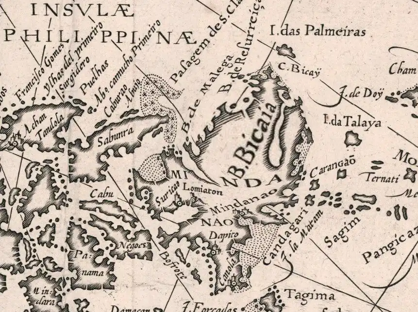
The orientation of the Philippines is rotated 90° to the left, so East is where North should be, making the placement of Bicaia in accordance with the Vizaya of Puerta and Urdaneta.
2.) Puerta’s Catile is included in the 1744 map by Pedro Murillo Velarde as Catel. The neighbouring towns of Bislig and Hinatoan are correctly placed north of Catel, making Velarde’s map highly accurate as they correctly correspond to what is known today.
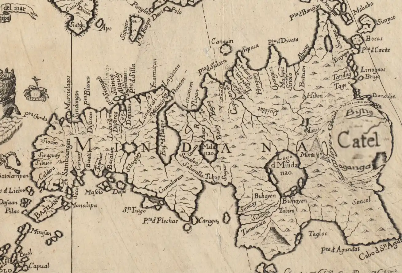
The eastern edge where Catel and its immediate neighbouring towns are now part of Davao Oriental.
3.) The other supposed provinces of Vizaya are more difficult to ascertain. It’s possible that Bixaliá may simply have been Bislig, but one can only surmise. The closest marker for Ratabaluy can be found in the 1587 map by Urbano Monti, where it is spelled as Catabalu. By mere phonetic resemblance, the possible connection between modern Cotabato and Catabalu is uncanny and intriguing.
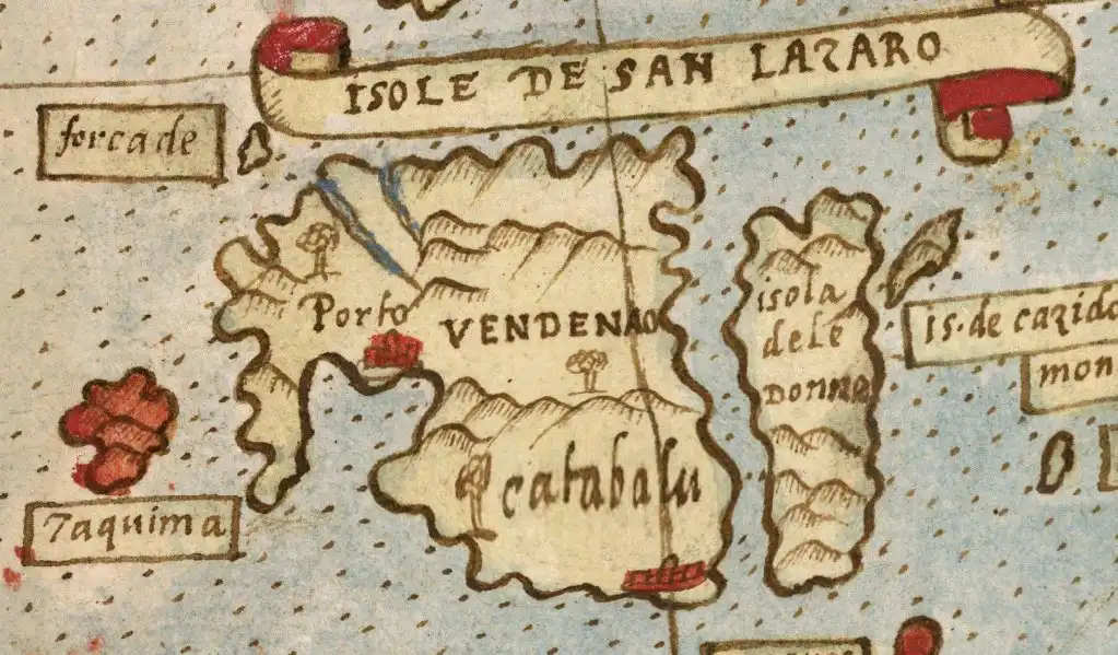
If Catabalu is indeed Ratabaluy, then it’s possible that it is located on the southeast edge of Mindanao, but as this map is quite crude, given that it positions Luzon and Visayas on the east of Mindanao, one has to take the information given by this map with tons of salt.
With maps and manuscripts solidifying the claim, there should be no more doubt about the existence of a southern Visayas in Mindanao. What remains indefinite is a question of toponymy: why was it called Vizaya? Puerta and Urdaneta offer no explanation, but another mariner, a member of the Saavedra voyage, has the answer. Vicencio de Napoles notes in his report that the coast was called Vizaya because that was the “nombre de los naturales de la tierra” (“name of the natives of the land”).10 This completes the puzzle.
No one alive knows the real origins of the Bisaya people. The dearth of historical records prior to the arrival of the Spaniards makes the search for their ancestry acutely perplexing, enough to cause frustration to the point that some—including academics—resort to believing false conjectures as a convenient recompense.11 But what we do know, from piecing the pieces together, is that by the 16th century the Bisaya had populated not just the islands that now comprise the Visayas, but they also formed communities in Mindanao, so much so that parts of the island were even known as Vizaya because of their prominent presence.
Subsequent migrations of peoples within the archipelago since the arrival of the Spaniards have made the populations of certain communities relatively homogeneous. So while the region of Visayas is named after its people, not all of its inhabitants are ethnically Bisaya. The same is true with Mindanao where more than 50% of its residents have Visayan ethnicity (25.8% Cebuano, 18.4% Bisaya/Binisaya, and 8.2% Hiligaynon) according to a 2005 Philippine Statistics Office dispatch. What might explain this curious abundance? The long history of Bisaya communities in Mindanao may have facilitated the easy traffic of Bisaya sailors into the island. Groups of Bisaya forced to leave their homes for various reasons may have sailed to Mindanao to find better prospects as they were wary of Bisaya communities already existing there. Entrepreneurial Bisaya took advantage of this nautical network like Puerta’s master who had business affiliations in Cebu. The absence of artificial borders also allowed the Bisaya to claim certain portions of land for their own, and when territorial disputes arose, they were ready to resolve things peacefully with warfare which they were particularly fond of and excelled in.12 This brand of Visayan diplomacy was witnessed firsthand by the Spaniards, and no one is better suited to testify of its quality than Puerta, whose captain and fellow crewmen were the recipients of such savvy policy. Needless to say, the (historic) results speak for themselves: had the Bisaya turned passive and left Puerta and the rest to themselves, we wouldn’t have known of the three provinces of Vizaya and what had happened to the remaining members of the Armada de Maluco.
-
Coleccion de los viajes y descubrimientos que hicieron por mar los españoles desde fines del siglo XV, con varios documentos inéditos concernientes á la historia de la Marina Castellana y de los establecimientos españoles de Indias, ed. Martin Fernandez de Navarrete, vol. 5 (Madrid: Imprenta Nacional, 1837), 471. ↩︎
-
Henry Funtecha, “The History and Culture of Boats and Boat-Building in the Western Visayas”, Philippine Quarterly of Culture and Society 28, no. 2 (2000): 117. ↩︎
-
Miguel de Loarca, “Relacion de Las Yslas Filipinas,” in The Philippine Islands: 1493-1998, eds. Emma Blair and James Robertson, vol. 5 (1582–1583) (Cleveland, OH: The Arthur H. Clarke Company, 1903), 121. ↩︎
-
Harry Kelsey, The First Circumnavigators: Unsung Heroes of the Age of Discovery (New Haven: Yale University Press, 2016), 39. ↩︎
-
Coleccion de los viajes, 408. ↩︎
-
James Burney, A Chronological History of the Discoveries in the South Sea or Pacific Ocean (London: Luke Hansard, 1803), 142. ↩︎
-
Ibid., 57. ↩︎
-
Miguel Rodrigues Lourenço, “Before the Philippines: textual and cartographical representations of Mindanao in sexteenth-century Portuguese sources”, South East Asia Research 29, no. 2 (2021): 4-5. ↩︎
-
Coleccion de los viajes, 471. ↩︎
-
Colección de documentos inéditos relativos al descubrimiento, conquista y organización de las antiguas posesiones españolas en América y Oceanía, sacados de los Archivos del Reino, y muy especialmente del de Indias, vol. 5 (Madrid: Imp. de M. Bernaldo de Quirós, 1866): 90. ↩︎
-
Lourdes Rausa-Gomez, “Sri Vijaya and Madjapahit”, Philippine Studies 15, no. 1 (1967): 77-81. ↩︎
-
Loarca, “Relacion Relacion de Las Yslas Filipinas”, 116-117. ↩︎